Sedgwick County

|
|
Sedgwick County |

|
Help us direct future mapping activities by leaving your voluntary comments here.
Comments about how you are using these maps are especially appreciated. Thank you!
Download the map from these links:

|

|
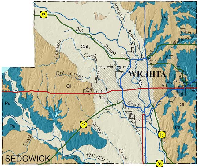
Lane, C.W., and Miller, D.E., 1991, Geologic map, Sedgwick County: Kansas Geological Survey, Map M-25, scale 1:50,000, 42 x 54 inches
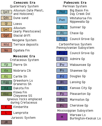
Paper copies of the complete map (with stratigraphic column and legend info) can be purchased from the Kansas Geological Survey, 1930 Constant Ave., Lawrence, KS 66047 (or phone 785-864-3965) and at 4150 W. Monroe St., Wichita, KS 67209-2640 (phone 316-943-2343).
Geohydrology of Sedgwick County, Kansas, by Charles W. Lane and Don E. Miller. Originally published in 1965 as Kansas Geological Survey Bulletin 176, this online version has been created because the published version is currently out of print.
As part of U.S. Geological National Cooperative Geologic Mapping Program (STATEMAP), the KGS has produced 7 1/2 minute quadrangle maps produced as part of the Sedgwick County geologic mapping project.
Parcell, W.C., Sinclair, J.T., and Lahey, M.L., 2015, Preliminary surficial geology of the Sedgwick County portion of the Greenwich quadrangle, Kansas: Kansas Geological Survey, Open-file Report 2015-13, 1 sheet, scale 1:24,000, unpublished [PDF available online]
Parcell, W.C., Sinclair, J.T., and Lahey, M.L., 2015, Preliminary surficial geology of the Valley Center quadrangle, Sedgwick County, Kansas: Kansas Geological Survey, Open-file Report 2015-14, 1 sheet, scale 1:24,000, unpublished [PDF available online]
Parcell, W.C., Dinkel, G.L., and Curtis, M.D., 2016, Preliminary surficial geology of the Colwich quadrangle, Sedgwick County, Kansas: Kansas Geological Survey, Open-file Report 2016-17, 1 sheet, scale 1:24,000, unpublished [PDF available online]
Parcell, W.C., Dinkel, G.L., and Curtis, M.D., 2016, Preliminary surficial geology of the Maize quadrangle, Sedgwick County, Kansas: Kansas Geological Survey, Open-file Report 2016-18, 1 sheet, scale 1:24,000, unpublished [PDF available online]
Parcell, W.C., Dinkel, G.L., Post, S.D., and Dunham, J.W., 2017, Preliminary surficial geology of the Sedgwick County portion of the Bentley quadrangle, Kansas: Kansas Geological Survey, Open-file Report 2017-25, 1 sheet, scale 1:24,000, unpublished [PDF available online]
Parcell, W.C., Dinkel, G.L., Post, S.D., and Dunham, J.W., 2017, Preliminary surficial geology of the Sedgwick County portions of the Mount Hope and Patterson quadrangles, Kansas: Kansas Geological Survey, Open-file Report 2017-26, 1 sheet, scale 1:24,000, unpublished [PDF available online]
Parcell, W.C., Dinkel, G.L., Post, S.D., and Dunham, J.W., 2017, Preliminary surficial geology of the Sedgwick County portion of the Sedgwick quadrangle, Kansas: Kansas Geological Survey, Open-file Report 2017-27, 1 sheet, scale 1:24,000, unpublished [PDF available online]
Parcell, W.C., Dinkel, G.L., Post, S.D., and Dunham, J.W., 2017, Preliminary surficial geology of the Sedgwick County portion of the Sedgwick NE quadrangle, Kansas: Kansas Geological Survey, Open-file Report 2017-28, 1 sheet, scale 1:24,000, unpublished [PDF available online]
Parcell, W.C., Dinkel, G.L., Post, S.D., and Dunham, J.W., 2017, Preliminary surficial geology of the Sedgwick County portion of the Whitewater quadrangle, Kansas: Kansas Geological Survey, Open-file Report 2017-29, 1 sheet, scale 1:24,000, unpublished [PDF available online]
Parcell, W.C., Dinkel, G.L., Post, S.D., and Dunham, J.W., 2018, Preliminary surficial geology of the Sedgwick County portion of the Andover quadrangle, Kansas: Kansas Geological Survey, Open-file Report 2018-10, 1 sheet, scale 1:24,000, unpublished [PDF available online]
Parcell, W.C., Dinkel, G.L., Post, S.D., and Dunham, J.W., 2018, Preliminary surficial geology of the Wichita East quadrangle, Sedgwick County, Kansas: Kansas Geological Survey, Open-file Report 2018-11, 1 sheet, scale 1:24,000, unpublished [PDF available online]
Parcell, W.C., Swanson, W.J., Wernert, J.A., and Dunham, J.W., 2019, Preliminary surficial geology of the Goddard quadrangle, Sedgwick County, Kansas: Kansas Geological Survey, Open-file Report 2019-11, 1 sheet, scale 1:24,000, unpublished [PDF available online]
Parcell, W.C., Swanson, W.J., Wernert, J.A., and Dunham, J.W., 2019, Preliminary surficial geology of the Wichita West quadrangle, Sedgwick County, Kansas: Kansas Geological Survey, Open-file Report 2019-12, 1 sheet, scale 1:24,000, unpublished [PDF available online]
Cartographic Services, Kansas Geological Survey
Updated December 9, 2020
Comments to webadmin@kgs.ku.edu
URL=http://www.kgs.ku.edu/General/Geology/County/rs/sedgwick.html