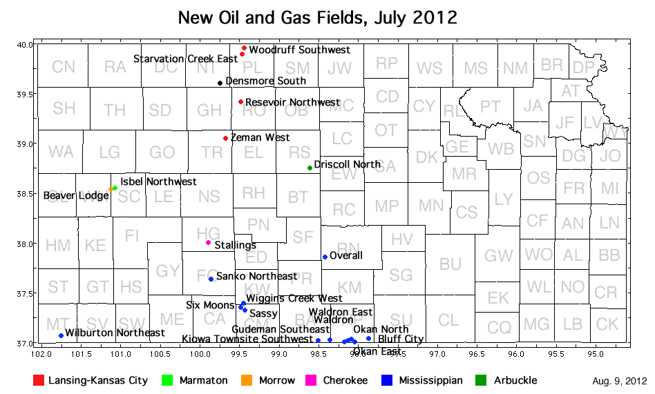
| Oil and Gas Fields Added, July 2012 | ||

| Field | Well | Operator | API Number | Latitude | Longitude | Location | Spot | Pay Zone |
|---|---|---|---|---|---|---|---|---|
| Beaver Lodge | David 1-32 | New Gulf Operating LLC, T. sec. 32 | 15-171-20874 | 38.5367715 | -101.10498 | sec. 32, T. 17 S., R. 34 W. | SE SE NW NW | Morrow |
| Bluff City | Greve 33-1 | Primexx Operating Corp. | 15-077-21763 | 37.0397031 | -97.872018 | sec. 33, T. 34 S., R. 5 W. | SW SW | Mississippian |
| Densmore South | McKinley 1 | Castle Resources, Inc. | 15-137-20604 | 39.6011306 | -99.75162 | sec. 24, T. 5 S., R. 22 W. | NW SE NE SW | ? |
| Driscoll North | Weber 1 | Jason Oil Company, LLC | 15-167-23781 | 38.7506901 | -98.611447 | sec. 13, T. 15 S., R. 12 W. | NW NE SW NW | Arbuckle |
| Gudeman Southeast | Schrock 3510 12-1H | Shell Gulf of Mexico Inc. | 15-007-23770-0100 | 37.0125536 | -98.36228 | sec. 12, T. 35 S., R. 10 W. | SW NE NW SW | Mississippian |
| Isbel Northwest | Krug 1-28 | New Gulf Operating LLC | 15-171-20875 | 38.5432296 | -101.08357 | sec. 28, T. 17 S., R. 34 W. | NW NE SE SW | Marmaton |
| Kiowa Townsite Southwest | Millie 'A' 1 | Chieftain Oil Co., Inc. | 15-007-23829 | 37.0002888 | -98.504825 | sec. 15, T. 35 S., R. 11 W. | NW SE SE NW | Mississippian |
| Okan East | Hopkins 1-14H | SandRidge Exploration and Production LLC | 15-077-21791-0100 | 36.9988543 | -98.039484 | sec. 14, T. 35 S., R. 7 W. | S2 S2 SE SE | Mississippian |
| Okan North | Cather 1-4H | SandRidge Exploration and Production LLC | 15-077-21829-0100 | 37.0226724 | -98.090375 | sec. 4, T. 35 S., R. 7 W. | SE SW SW SW | Mississippian |
| Overall | Overall 1-21H | Unit Petroleum Company | 15-155-21585-0100 | 37.8541661 | -98.419216 | sec. 21, T. 25 S., R. 10 W. | SW SE SE SE | Mississippian |
| Reservoir Northwest | Pettijohn 1 | Black Diamond Oil, Inc. | 15-163-24012 | 39.4188477 | -99.48416 | sec. 30, T. 7 S., R. 19 W. | NE NW SE NW | Lansing-Kansas City |
| Sanko Northeast | Riegel 1-9 | Vincent Oil Corp. | 15-057-20786 | 37.6306665 | -99.85012 | sec. 9, T. 28 S., R. 23 W. | SW NW NW NW | Mississippian |
| Sassy | Ellis 1-19H | SandRidge Exploration and Production LLC | 15-033-21605-0100 | 37.3228574 | -99.433656 | sec. 30, T. 31 S., R. 19 W. | N2 N2 NW NW | Mississippian |
| Six Moons | PTL 1-15H | SandRidge Exploration and Production LLC | 15-033-21613-0100 | 37.3517821 | -99.474208 | sec. 15, T. 31 S., R. 20 W. | NE NW NE NE | Mississippian |
| Stallings | Stallings 1-31 | Deutsch Oil Co. | 15-083-21744 | 38.0052685 | -99.89352 | sec. 31, T. 23 S., R. 23 W. | SW SW NE SW | Mississippian |
| Starvation Creek East | Brands Unit 1 | Bach Oil Production | 15-147-20668 | 39.9010811 | -99.462105 | sec. 4, T. 2 S., R. 19 W. | SE SW SE SE | Lansing-Kansas City |
| Waldron | LIT Trust 1-14H | SandRidge Exploration and Production LLC | 15-077-21796-0100 | 36.9985121 | -98.161746 | sec. 14, T. 35 S., R. 8 W. | S2 S2 SW SW | Mississippian |
| Waldron East | Brad 1-12H | SandRidge Exploration and Production LLC | 15-077-21795-0100 | 37.0077344 | -98.139096 | sec. 12, T. 35 S., R. 8 W. | S2 S2 SE SW | Mississippian |
| Wiggins Creek West | Iris 1-1H | SandRidge Exploration and Production LLC | 15-033-21611-0100 | 37.3810336 | -99.451004 | sec. 1, T. 31 S., R. 20 W. | N2 N2 NW NW | Mississippian |
| Wilburton Northeast | Stanford 'A' 3 (changed from Stanford 'C' 2) |
Oxy USA, Inc. | 15-129-21939 | 37.0608675 | -101.74942 | sec. 26, T. 34 S., R. 41 W. | NW NW NE SW | Mississippian |
| Woodruff Southwest | Pete's Pond 1 | Bach Oil Production | 15-147-20671 | 39.9633679 | -99.431788 | sec. 14, T. 1 S., R. 19 W. | NE SE NE SW | Lansing-Kansas City |
| Zeman West | Armbruster et al. 1-32 | Samuel Gary Jr. and Assoc., Inc. | 15-195-22766 | 39.0509559 | -99.676583 | sec. 32, T. 11 S., R. 21 W. | S2 N2 N2 S2 | Lansing-Kansas City |
|
Kansas Geological Survey, Oil and Gas Information Updated August 9, 2012 Comments to webadmin@kgs.ku.edu The URL for this page is http://www.kgs.ku.edu/Magellan/Field/NMC/july_2012.html |