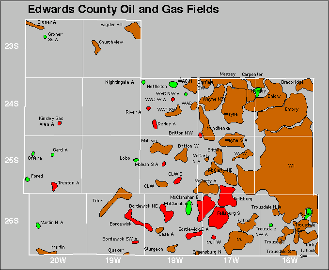
| Year | Oil | Gas | ||||
|---|---|---|---|---|---|---|
| Production (bbls) |
Wells | Cumulative (bbls) |
Production (mcf) |
Wells | Cumulative (mcf) |
|
| 1995 | 304,120 | 359 | 16,523,923 | 2,826,747 | 195 | 174,456,253 |
| 1996 | 310,050 | 335 | 16,833,973 | 2,807,119 | 200 | 177,263,372 |
| 1997 | 276,820 | 325 | 17,110,793 | 2,859,239 | 198 | 180,122,611 |
| 1998 | 227,223 | 310 | 17,338,016 | 2,675,420 | 198 | 182,798,031 |
| 1999 | 213,129 | 302 | 17,551,145 | 2,406,111 | 206 | 185,204,142 |
| 2000 | 203,924 | 290 | 17,755,069 | 2,337,765 | 206 | 187,541,907 |
| 2001 | 212,719 | 293 | 17,967,788 | 2,398,369 | 217 | 189,940,276 |
| 2002 | 228,327 | 284 | 18,196,115 | 2,721,212 | 215 | 192,661,488 |
| 2003 | 217,278 | 277 | 18,413,393 | 2,783,456 | 218 | 195,444,944 |
| 2004 | 231,771 | 287 | 18,645,164 | 2,080,444 | 221 | 197,525,388 |
| 2005 | 218,493 | 266 | 18,863,657 | 2,181,186 | 224 | 199,706,574 |
| 2006 | 227,732 | 295 | 19,091,389 | 2,320,998 | 231 | 202,027,572 |
| 2007 | 250,785 | 286 | 19,342,174 | 2,648,201 | 235 | 204,675,773 |
| 2008 | 239,431 | 302 | 19,581,605 | 2,475,279 | 238 | 207,151,052 |
| 2009 | 198,067 | 282 | 19,779,672 | 2,018,669 | 229 | 209,169,721 |
| 2010 | 172,008 | 280 | 19,951,680 | 1,790,490 | 211 | 210,960,211 |
| 2011 | 156,588 | 277 | 20,108,268 | 1,612,217 | 211 | 212,572,428 |
| 2012 | 156,012 | 265 | 20,264,280 | 1,516,114 | 204 | 214,088,542 |
| 2013 | 153,232 | 289 | 20,417,512 | 1,284,913 | 191 | 215,373,455 |
| 2014 | 166,778 | 280 | 20,584,290 | 1,276,647 | 198 | 216,650,102 |
| 2015 | 170,903 | 276 | 20,755,193 | 1,147,670 | 188 | 217,797,772 |
| 2016 | 155,573 | 246 | 20,910,766 | 1,008,802 | 161 | 218,806,574 |
| 2017 | 151,946 | 231 | 21,062,712 | 894,349 | 148 | 219,700,923 |
| 2018 | 146,347 | 212 | 21,209,059 | 782,437 | 142 | 220,483,360 |
| 2019 | 136,207 | 199 | 21,345,266 | 620,811 | 128 | 221,104,171 |
| 2020 | 118,695 | 186 | 21,463,961 | 576,865 | 111 | 221,681,036 |
| 2021 | 120,875 | 203 | 21,584,836 | 512,381 | 96 | 222,193,417 |
| 2022 | 110,744 | 176 | 21,695,580 | 581,649 | 105 | 222,775,066 |
| 2023 | 112,342 | 168 | 21,807,922 | 573,472 | 99 | 223,348,538 |
| 2024 | 95,654 | 172 | 21,903,576 | 435,879 | 82 | 223,784,417 |


Abandoned