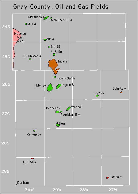
| Year | Oil | Gas | ||||
|---|---|---|---|---|---|---|
| Production (bbls) |
Wells | Cumulative (bbls) |
Production (mcf) |
Wells | Cumulative (mcf) |
|
| 1995 | 131,444 | 38 | 2,965,985 | 120,410 | 3 | 1,100,308 |
| 1996 | 120,350 | 39 | 3,086,335 | 203,421 | 4 | 1,303,729 |
| 1997 | 113,930 | 40 | 3,200,265 | 131,833 | 4 | 1,435,562 |
| 1998 | 108,835 | 39 | 3,309,100 | 110,995 | 4 | 1,546,557 |
| 1999 | 106,338 | 36 | 3,415,438 | 112,122 | 4 | 1,658,679 |
| 2000 | 101,539 | 36 | 3,516,977 | 97,513 | 4 | 1,756,192 |
| 2001 | 92,888 | 36 | 3,609,865 | 93,418 | 3 | 1,849,610 |
| 2002 | 87,468 | 35 | 3,697,333 | 66,438 | 3 | 1,916,048 |
| 2003 | 76,869 | 36 | 3,774,202 | 73,962 | 3 | 1,990,010 |
| 2004 | 70,020 | 34 | 3,844,222 | 82,690 | 5 | 2,072,700 |
| 2005 | 66,209 | 37 | 3,910,431 | 175,130 | 5 | 2,247,830 |
| 2006 | 70,024 | 36 | 3,980,455 | 286,373 | 11 | 2,534,203 |
| 2007 | 65,176 | 39 | 4,045,631 | 234,611 | 11 | 2,768,814 |
| 2008 | 68,692 | 38 | 4,114,323 | 241,254 | 12 | 3,010,068 |
| 2009 | 74,373 | 42 | 4,188,696 | 314,671 | 16 | 3,324,739 |
| 2010 | 92,717 | 43 | 4,281,413 | 292,578 | 16 | 3,617,317 |
| 2011 | 90,190 | 46 | 4,371,603 | 284,491 | 15 | 3,901,808 |
| 2012 | 214,865 | 64 | 4,586,468 | 243,560 | 15 | 4,145,368 |
| 2013 | 279,324 | 74 | 4,865,792 | 954,459 | 27 | 5,099,827 |
| 2014 | 236,751 | 79 | 5,102,543 | 973,867 | 29 | 6,073,694 |
| 2015 | 208,474 | 77 | 5,311,017 | 785,734 | 29 | 6,859,428 |
| 2016 | 133,877 | 77 | 5,444,894 | 580,439 | 24 | 7,439,867 |
| 2017 | 124,180 | 71 | 5,569,074 | 472,198 | 27 | 7,912,065 |
| 2018 | 113,707 | 73 | 5,682,781 | 340,304 | 22 | 8,252,369 |
| 2019 | 106,362 | 74 | 5,789,143 | 342,159 | 21 | 8,594,528 |
| 2020 | 91,801 | 68 | 5,880,944 | 360,358 | 20 | 8,954,886 |
| 2021 | 84,421 | 71 | 5,965,365 | 250,982 | 23 | 9,205,868 |
| 2022 | 71,127 | 72 | 6,036,492 | 278,553 | 19 | 9,484,421 |
| 2023 | 64,316 | 74 | 6,100,808 | 256,612 | 21 | 9,741,033 |
| 2024 | 59,617 | 59 | 6,160,425 | 180,441 | 21 | 9,921,474 |


Abandoned