| Year | Oil | Gas | ||||
|---|---|---|---|---|---|---|
| Production (bbls) |
Wells | Cumulative (bbls) |
Production (mcf) |
Wells | Cumulative (mcf) |
|
| 1995 | 780,976 | 1961 | 293,740,118 | 6,602 | 3 | 402,453 |
| 1996 | 755,742 | 1687 | 294,495,860 | 1,539 | 1 | 403,992 |
| 1997 | 735,080 | 1583 | 295,230,940 | 7,956 | 2 | 411,948 |
| 1998 | 614,998 | 1553 | 295,845,938 | 4,487 | 1 | 416,435 |
| 1999 | 557,146 | 1400 | 296,403,084 | 1,929 | 1 | 418,364 |
| 2000 | 596,150 | 1431 | 296,999,234 | 1,476 | 1 | 419,840 |
| 2001 | 554,976 | 1396 | 297,554,210 | 5,166 | 1 | 425,006 |
| 2002 | 543,798 | 1386 | 298,098,008 | 2,768 | 1 | 427,774 |
| 2003 | 534,195 | 1369 | 298,632,203 | 1,771 | 1 | 429,545 |
| 2004 | 535,171 | 1346 | 299,167,374 | 1,079 | 1 | 430,624 |
| 2005 | 533,431 | 1393 | 299,700,805 | 352 | 1 | 430,976 |
| 2006 | 545,172 | 1389 | 300,245,977 | - | - | 430,976 |
| 2007 | 493,195 | 1387 | 300,739,172 | - | - | 430,976 |
| 2008 | 487,661 | 1398 | 301,226,833 | - | - | 430,976 |
| 2009 | 466,793 | 1398 | 301,693,626 | - | - | 430,976 |
| 2010 | 465,196 | 1388 | 302,158,822 | - | - | 430,976 |
| 2011 | 440,266 | 1431 | 302,599,088 | - | - | 430,976 |
| 2012 | 462,116 | 1438 | 303,061,204 | - | - | 430,976 |
| 2013 | 442,716 | 1429 | 303,503,920 | - | - | 430,976 |
| 2014 | 441,345 | 1435 | 303,945,265 | - | - | 430,976 |
| 2015 | 409,419 | 1431 | 304,354,684 | - | - | 430,976 |
| 2016 | 365,004 | 1355 | 304,719,688 | - | - | 430,976 |
| 2017 | 357,974 | 1387 | 305,077,662 | - | - | 430,976 |
| 2018 | 355,081 | 1341 | 305,432,743 | - | - | 430,976 |
| 2019 | 341,313 | 1316 | 305,774,056 | - | - | 430,976 |
| 2020 | 317,677 | 1272 | 306,091,733 | - | - | 430,976 |
| 2021 | 303,523 | 1219 | 306,395,256 | - | - | 430,976 |
| 2022 | 295,476 | 1181 | 306,690,732 | - | - | 430,976 |
| 2023 | 301,243 | 1183 | 306,991,975 | - | - | 430,976 |
| 2024 | 267,070 | 1097 | 307,259,045 | - | - | 430,976 |


| Abandoned | ||
|---|---|---|
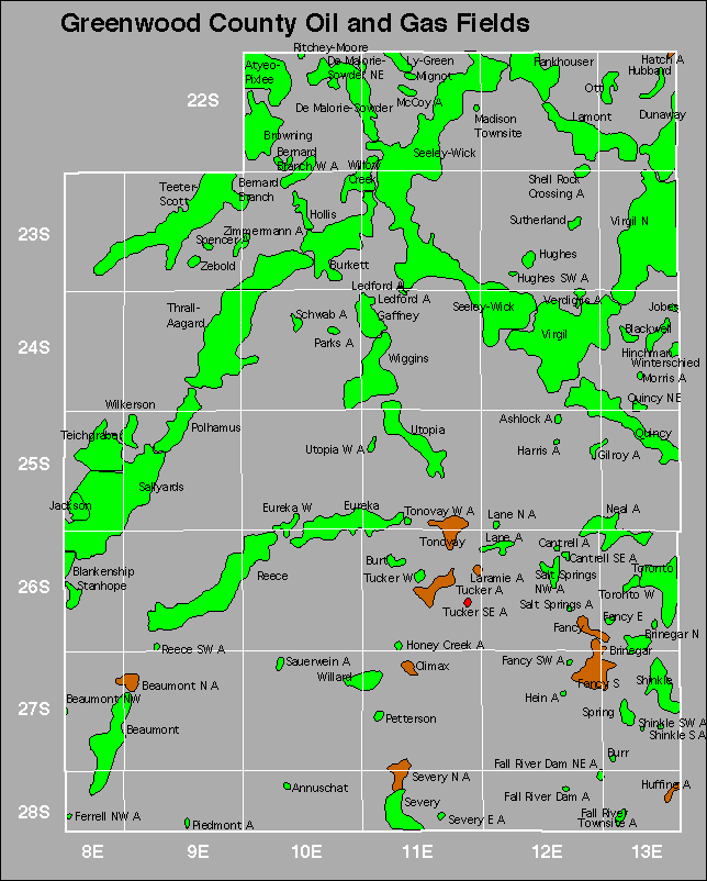
| Ashlock Ferrell North Gilroy Harris Honey Creek Ledford |
Mccoy Mignot Morris Piedmont Salt Springs Shell Rock Crossing |
Spencer Tonovay West Verdigris |