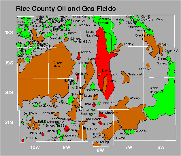
| Year | Oil | Gas | ||||
|---|---|---|---|---|---|---|
| Production (bbls) |
Wells | Cumulative (bbls) |
Production (mcf) |
Wells | Cumulative (mcf) |
|
| 1995 | 961,415 | 1412 | 328,750,274 | 800,729 | 90 | 67,761,882 |
| 1996 | 900,307 | 1144 | 329,650,581 | 541,260 | 66 | 68,303,142 |
| 1997 | 841,724 | 1011 | 330,492,305 | 572,810 | 80 | 68,875,952 |
| 1998 | 720,598 | 973 | 331,212,903 | 569,985 | 72 | 69,445,937 |
| 1999 | 761,953 | 838 | 331,974,856 | 564,700 | 59 | 70,010,637 |
| 2000 | 780,538 | 922 | 332,755,394 | 560,177 | 55 | 70,570,814 |
| 2001 | 726,554 | 897 | 333,481,948 | 568,520 | 58 | 71,139,334 |
| 2002 | 718,552 | 816 | 334,200,500 | 571,265 | 58 | 71,710,599 |
| 2003 | 694,513 | 810 | 334,895,013 | 540,038 | 61 | 72,250,637 |
| 2004 | 705,710 | 807 | 335,600,723 | 849,460 | 61 | 73,100,097 |
| 2005 | 726,078 | 801 | 336,326,801 | 677,156 | 68 | 73,777,253 |
| 2006 | 750,773 | 830 | 337,077,574 | 777,231 | 69 | 74,554,484 |
| 2007 | 776,932 | 837 | 337,854,506 | 427,270 | 39 | 74,981,754 |
| 2008 | 837,615 | 840 | 338,692,121 | 510,254 | 66 | 75,492,008 |
| 2009 | 786,083 | 818 | 339,478,204 | 691,741 | 71 | 76,183,749 |
| 2010 | 801,180 | 845 | 340,279,384 | 647,512 | 67 | 76,831,261 |
| 2011 | 814,784 | 871 | 341,094,168 | 647,081 | 68 | 77,478,342 |
| 2012 | 824,685 | 887 | 341,918,853 | 501,430 | 69 | 77,979,772 |
| 2013 | 840,715 | 909 | 342,759,568 | 420,738 | 65 | 78,400,510 |
| 2014 | 858,834 | 926 | 343,618,402 | 316,412 | 57 | 78,716,922 |
| 2015 | 824,542 | 930 | 344,442,944 | 309,116 | 58 | 79,026,038 |
| 2016 | 722,189 | 916 | 345,165,133 | 218,990 | 48 | 79,245,028 |
| 2017 | 669,404 | 924 | 345,834,537 | 208,226 | 49 | 79,453,254 |
| 2018 | 625,031 | 920 | 346,459,568 | 214,260 | 51 | 79,667,514 |
| 2019 | 581,582 | 913 | 347,041,150 | 142,960 | 47 | 79,810,474 |
| 2020 | 500,237 | 870 | 347,541,387 | 107,701 | 24 | 79,918,175 |
| 2021 | 522,543 | 869 | 348,063,930 | 104,218 | 26 | 80,022,393 |
| 2022 | 509,854 | 857 | 348,573,784 | 131,570 | 36 | 80,153,963 |
| 2023 | 524,011 | 829 | 349,097,795 | 135,268 | 31 | 80,289,231 |
| 2024 | 455,094 | 812 | 349,552,889 | 120,719 | 29 | 80,409,950 |


Gas Storage Fields