The Siefkes Study Site is part of the Mineral Intrusion Study Area, a region of intensive study by the Geohydrology Section of the Kansas Geological Survey (Young, et al. [2]; Buddemeier, et al. [3]). Site characterization and ground water modeling of the Siefkes Study Site were undertaken in order to improve understanding of ground water flow within the area. Two monitoring wells were placed within the proximity of the irrigation well to monitor subsurface salinity levels and provide lithological information. Ground water modeling of the area used information provided by these ground-water monitoring wells. However, the limited control points severely limited site characterization and subsequent ground water modeling.
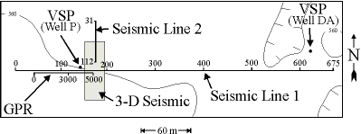
In order to improve site characterization a series of geophysical investigations were performed (Figure 2). The geophysical data collected include a ground-penetrating radar profile imaging the very-near surface above the water table, 2-D and 3-D near-surface seismic reflection data imaging the Permian bedrock surface and deeper rock units, and near-surface vertical seismic profile data used to depth-tie the seismic data with lithological information.
Once time-scaled, the GPR data were loaded into the computer workstation and viewed. The GPR data were treated as stacked seismic data, opening up the possibility of using conventional post-stack seismic reflection tools to process the data. Trace balancing and gains were applied in order to give the profile an even appearance and to accentuate anomalies. Other digital processing techniques included bandpass filtering (to remove high-frequency multiple events caused by the water table), and f-k filtering (to reduce horizontal linear events and accentuate anomalies).
Several features of interest were found along the GPR profile. A portion of the profile over a subsurface feature is interpreted as a portion of a paleo-stream channel, with the interpreted point bar and cut bank highlighted (Figure 3). Also seen is a diffraction, believed to be caused by the remains of a shot point station from the seismic data collected in the area. The GPR data indicates that the very-near surface is relatively laterally and vertically heterogeneous in nature (Figure 3). This heterogeneity can greatly affect the infiltration of fresh water from the surface into the subsurface and should be incorporated to develop accurate models of aquifer recharge.