

Kansas Geological Survey, Public Information Circular (PIC) 2
Salt Contamination of Ground Water in South Central Kansas--Part 4 of 5
Groundwater Management Districts 2 and 5 have established ground-water-quality monitoring networks and data bases to provide basic information to ground-water users. Additional information is available from other local, state, and federal agencies.
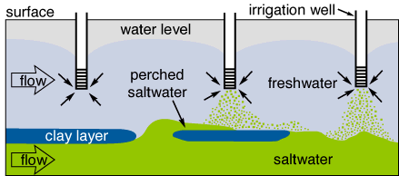
Figure 3A--The undisturbed aquifer contains saltwater at its base, but saltwater does not rise much above the level of the discontinuous clay layer.

Figure 3B--During pumping, saltwater moves toward the discharge points, and upconing beneath the pumping wells occurs.

High-capacity irrigation or municipal-supply wells have zones of influence that may extend more than a mile from the well. These wells can dramatically alter water-table elevations and ground-water- flow directions. Because ground water moves relatively slowly, it may take several years for an underground source of salt contamination to be diverted to the well or nearby wells. Once an area is contaminated, remediation by human modification is difficult, and natural processes are slow.
Severe drought can lead to salt-contamination problems not observed during normal or excess precipitation. During periods of little or no recharge, ground water continues to discharge naturally from freshwater aquifers, decreasing the thickness of the freshwater zone overlying the saltwater. Regional pumping is likely to be greater during droughts and can further decrease the thickness of the freshwater aquifer. Thus, upconing of saltwater can be more severe during extended droughts.


Kansas Geological Survey, Geology Extension
Web version Nov. 1995
http://www.kgs.ku.edu/Publications/pic2/pic2_4.html