
Kansas Geological Survey, Public Information Circular (PIC) 1
A User's Guide to Well-spacing Requirements for
the Dakota Aquifer in Kansas--Part 2 of 5
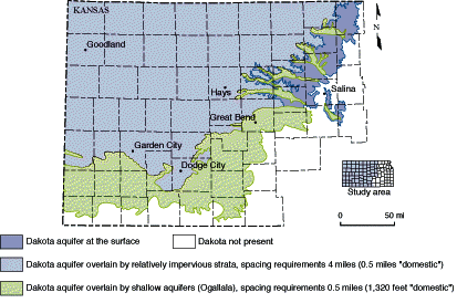
Figure 1--The Dakota aquifer in Kansas.


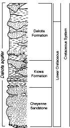
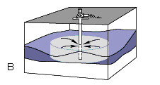
These irregular sandstone bodies were deposited during the early part of the Cretaceous Period of geologic history (approximately 90-100 million years ago) in river valleys and along ancient shorelines. Seas eventually covered most of what is now Kansas and the exposed land surfaces laid to the east. The river-deposited sandstone bodies occur in the lower two-thirds of the Dakota Formation and the Cheyenne Sandstone. They are ribbonlike in shape (figure 3A) and are up to 20 miles (32 km) in length, 1.5 miles (2.4 km) wide, and can be over 100 feet (30 m) thick. With some exceptions, these sandstone bodies are oriented in an east-west direction, parallel to the drainage direction. The shoreline sandstone bodies occur in the upper Dakota Formation and the Kiowa Formation. They are usually thin and sheetlike (figure 3B), typically up to 50 feet (15 m) thick and covering several square miles. The long axes of these sandstone bodies tend to be oriented in a north-south direction, parallel to the orientation of the ancient shorelines. In central Kansas, river-deposited sandstones dominate the upper part of the Dakota aquifer, but in western Kansas near the Kansas-Colorado border, shoreline sandstones are more dominant in the upper part of the aquifer. Both river-deposited and shoreline sandstones occur in the lower part of the Dakota aquifer throughout its extent.
Figure 3--Irregular sandstone bodies. A) river deposited sandstones,
B) shoreline sandstones. Arrows represent flow toward the well. Lighter shading
represents the volume affected by pumping a single well.


Kansas Geological Survey, Geology Extension
Web version Nov. 1995
http://www.kgs.ku.edu/Publications/pic1/pic1_2.html